Hovenweep National Monument
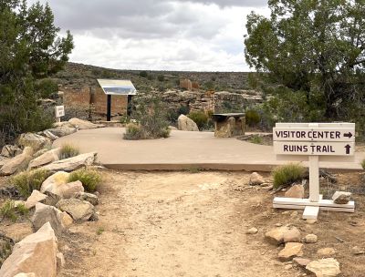
Off The Beaten Path But Worth the Detour
It was William Henry Jackson, the pioneer photographer of the 19th century, who gave Hovenweep National Monument its name. Famous for his work with the Hayden Survey party exploring Yellowstone, he visited the Hovenweep area in 1874.
He used the Ute/Paiute Indian word meaning “deserted valley” to describe the area and the name stuck. W.D. Huntington first reported these structures after he led a Mormon expedition into the area in 1854. This means that the Hovenweep structures were discovered more than 30 years before the more-famous Mesa Verde.
There are six major Hovenweep National Monument clusters all lying within a 20-mile (32km) drive of each other along the Utah-Colorado border. The units vary considerably in size.
The largest one is the 400-acre Square Tower Group where the Ranger Station is located. This group and Cajon Ruins are both located in Utah. We visited this amazing group of structures … the Square Tower Group … on our recent 1,800-mile road trip through southern Utah and into Colorado.
We used Blanding as our base. Hovenweep is 45 miles (takes just under an hour) southeast of Blanding. We were able to see Edge of the Cedars State Park Museum, eat a really mediocre steak, and drink no alcohol (dry town) in Blanding. Just kidding about the last two. Well, no, the steak was bad. And it is a dry town.
The drive takes you south of Blanding along US-191 for about 15 miles and then through the Navajo reservation along US-191 and then along Reservation Road. One thing we noticed about driving through Native American reservations. The speed limit always seems lower … sometimes 10-15 MPH.
I’m not sure if it is just a revenue stream (speeding tickets) or actually for safety. A little online research gives a variety of reasons none of which really pin down the seeming inconsistency.
Driving out to Hovenweep is a side-trip that I highly recommend especially if you are interested in Native American culture and history. We were thoroughly enthralled with our visit.
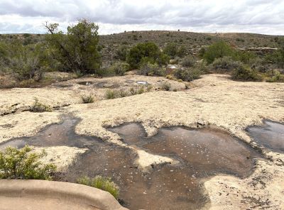
The Towers of Hovenweep National Monument
The canyon and mesa country of the San Juan River is home to many archaeological sites where the ancestors of today’s Pueblo Indian tribes lived. Many of these locations are still marked by round, square and D-shaped towers grouped at the heads of canyons.
It has been more than 700 years since anyone lived in them. Even so, they are still wondrous and awe-inspiring. The Smithsonian Institution (at least they didn’t try to shut this one down like the Grand Canyon) sent J.D. Fewkes to survey the area in 1917-18.
While the rest of the world was killing each other’s young men and civilians, he recommended that these structures be protected. In 1923, President Warren G. Harding declared Hovenweep a national monument.
Many of the ancient Puebloan dwellings stand right on the canyon rim. Some were built above isolated or irregular boulders. Most are still associated with springs and seeps near canyon heads.
The suggestion is that they were trying to protect something. Perhaps it was the extremely valuable water since they were agriculturalists.
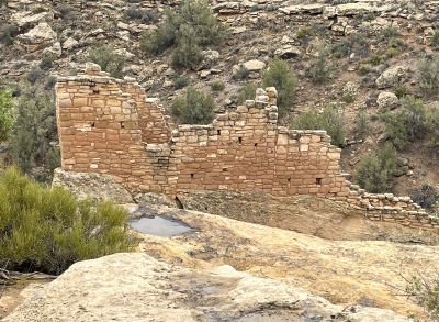
Out in the Middle of Nowhere
As you drive across the mostly flat, often featureless terrain to get to the Square Tower Group in Hovenweep, the first question that comes to mind is “why out here?” “How did they find this little canyon out in the middle of nowhere?”
Research shows that by the 1200’s, the population in the area had grown dramatically but much of the tree cover had been removed. Maybe drought and the depletion of surrounding resources dictated the ancestral Puebloans abrupt departure late in that decade.
There were only half a dozen or so vehicles in the parking lot when we got to the visitor center mid-morning. We went in to get some information and gain entrance. We have a lifetime National Parks pass (only $80 for seniors) and we have found it to be good for access to National Monuments also.
The young Ranger at the desk seemed almost disappointed that we would use this pass to gain entry rather than pay the full fee even though it was 100% valid. Sorry, smirking dude. That’s why we bought it.
The visit to the Square Tower Group in Hovenweep is essentially a hike. You have to hike around the top of the canyon to get to all the structures. He told us it was only 1 ½ miles. It was actually closer to 2 miles.
We saw some older and not so fit people along the trail that were clearly struggling. One of the Rangers was walking the trail likely checking on people like this. She was quite friendly and it was actually a little comforting to see her on the trail.
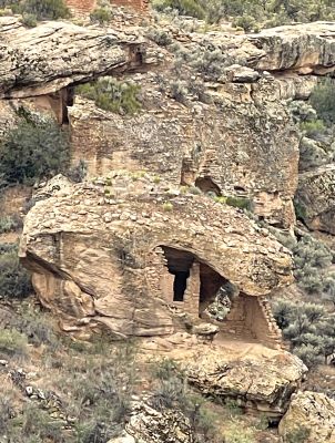
Six Major Hovenweep Clusters
We learned there are various theories about why Hovenweep’s towers were built. Storage buildings. Ceremonial buildings. Celestial observation towers.
Or perhaps they were defensive structures. As mentioned above, they did have a most vital resource to protect - their water supply.
The six major Hovenweep National Monument clusters all lie within a 20-mile (32km) drive of each other along the Utah-Colorado border. Four of these clusters are located in Colorado.
The units vary considerably in size. The largest one is the 400-acre Square Tower Group where the Ranger Station is located. This group and Cajon Ruins are both located in Utah.
We visited the Square Tower Group. It is a solitary and absolutely non-commercialized environment. In this remote and peaceful area, it is almost surreal walking around and getting up close to the structures.
The Colorado sites are Holly Ruins, Hackberry Canyon, Cutthroat Castle and Goodman Point. Hovenweep National Monument covers 785 acres.
Hiking The Tower Group Trail
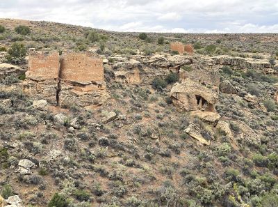
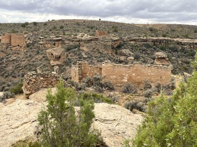
There are nine structures located along the canyon rim and down in the canyon at Tower Group. From the Visitor Center, you walk a short way to the canyon overlook. You head in either direction from there around the canyon rim as you can walk right up to most of the structures.
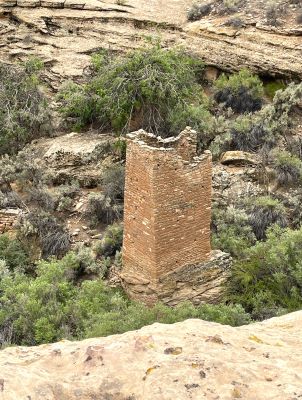
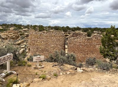
The structures are: Stronghold House, Unit Type House, Tower Point, Hovenweep Castle, Square Tower, Hovenweep House, Rim Rock House, Twin Towers and Eroded Boulder House.
It took us about an hour to navigate the trail along the top of the canyon rim. We stopped, observed and took a lot of photos. If you do the entire circuit, you have to follow the trail down in to the shallow canyon and then back up the other side either.
Depending on the direction you take, this descent is either near the beginning or the end. We went right so it was near the end. This could be, I can see, a little problematic if you aren’t in good physical condition.
One lady was definitely laboring as she tried to make it through this area. Anyone in good shape and who walks or hikes regularly shouldn’t have a problem.
What Does Hovenweep at
Square Tower Group Offer?
There is a visitor center containing exhibits and typical educational material about the area and monument. Water and the usual array of unhealthy snacks are also available.
Stock up on real food and supplies at either Cortez, CO or Blanding, UT before
you get to the monument though if you’re looking for health or nutrition.
Tread Lightly
Hovenweep’s archeological sites are unusually fragile. As in many areas of the arid southwest, crypto-biotic soils lie throughout the monument. These biological soil crusts are formed by living organisms and their by-products.
They create a surface crust of soil
particles bound together by organic materials. And they take years to recover …
if they ever do … when damaged.
Since my rule of thumb for common sense is that it is uncommon, I will mention
a few other “rules” here:
- Do not climb on the age-old walls. They are ancient. They can be damaged easily and so can you.
- Do not pick up artifacts.
- Hike only on established trails.
- Overnight stays are not allowed at any of the sites for obvious reasons. There is a nearby campground. See below.
- Mountain bikes are only allowed on the roadways. If you want to hit the trails hard, there are plenty of great trails on public lands in the surrounding area.
- Spring and fall are the best times to visit. Summers are very hot and very dry. Summer visitors should try to get there before 10:00 AM. If you happen to visit in winter, plan for storms. This is a remote and isolated place.
Where is Hovenweep National Monument?
Hovenweep National Monument is located a little north of the Four Corners area where Utah, Colorado, Arizona, and New Mexico join. The six site areas of Hovenweep are situated in both southeastern Utah and southwestern Colorado.
The Ranger Station is located 40 miles (64 km) east of Blanding, Utah near U.S. highways 191 and Hovenweep Road. It is 40 miles (64 km) west of Cortez, Colorado.
From Blanding or Bluff, UT, turn east off U.S. Highway 191 on Utah 262 to the Hatch Trading Post. Drive 16 miles (25.7 km) along Hovenweep Road.
From Cortez, CO, head southwest on U.S. Highway 160. Go 4 miles (6.4 km) south and then west on County Road G for 41 miles (66 km).
Camping
There are 31 camping spots in the Hovenweep Campground. It is open year-round and you can reserve through Recreation.gov. The campground is designed for tent camping although a few sites will accommodate RVs up to 36 feet long.
Groups are limited to eight people and two vehicles. Sites include tent pads, fire rings and picnic tables with shade structures. There are no hookups available. One campsite is wheelchair-accessible but is not designed for tent camping.
Conclusion
Although Hovenweep … and the Square Tower Group in particular … is quite isolated, I highly recommend a visit. I haven’t experienced the other Hovenweep sites but we thoroughly enjoyed our visit.
We visited and did the hike in early June so the weather was pleasant. I could see mid-summer being spectacularly hot so plan on early morning. It opens at 09:00.
Have A Comment or Story
About This Topic?
Do you have a comment or story about this article? Share it!


