San Rafael Swell
Most Treasured Yet Unknown
The San Rafael Swell is one of Utah’s most treasured ... yet unknown ... wilderness areas.
The Swell is found 28 miles (45 km) directly east of the town of Castle Dale. Castle Dale is 146.5 miles (236 km) southeast of Salt Lake City.
It is a gargantuan dome of rock thrust up by the earth’s interior millions of years ago. As nature did her work, various erosional factors created a masterpiece of buttes, canyons, mesas, and towering summits.
The San Rafael Swell is about 80 miles (128 km) long and 30 miles (48 km) wide.
Known as “The Little Grand Canyon”, its relative lack of accessibility has allowed it to remain somewhat undiscovered and unknown.
But the area offers stunning terrain and a wonderful convoluted series of hiking, biking, and game trails. You’ll find some of them well-marked and others not marked at all.
If you want to escape, the San Rafael Swell offers seclusion and wide-open spaces. Without having to travel too far from civilization.
Whether on foot, ATV, mountain bike, horse, or with your dog, you’re welcome here. Interstate 70 actually cuts through the middle of the area but is the only paved road to do so.
Many of the dirt and gravel roads are well maintained so you can drive a regular car if the weather allows it. The area is far from any services so you’ll need plenty of water and a full tank of gas.
Why Not a National Monument or Park?
With over 600,000 acres, the San San Rafael Swell area is designated as multi-use by the BLM. As you might imagine, there has been talk of designating parts of this area either a national monument or state park to “protect it”.
But it continues to be left to those who use it. And it seems to be doing just fine. Be sure to stay on established trails, the slick-rock, or in washes to ensure the always-fragile desert vegetation remains undisturbed.
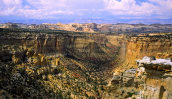
Wedge Overlook
From the Buckhorn Flat Junction – 12 ½ miles (20 km) inside the San Rafael Swell – head 6 miles (9.6 km) down the left fork. At the end of this road you’ll get to experience one of those moments mentioned on my home page. After which you’re never quite the same.
Looking down 1,000 feet below, you’ll get an unbelievable view of the “Little Grand Canyon”. With the serpentine San Rafael River winding its way through the canyon below.
Buckhorn Draw
Head back to Buckhorn Flat Junction and east on the same road you came in on. The road forks 2 miles (3.2 km) east of there. The left or north fork takes you through an amazing array of buttes, mesas, and pinnacles. It connects with Highway 6 at a point 16 miles (25.7 km) north of the town of Green River.
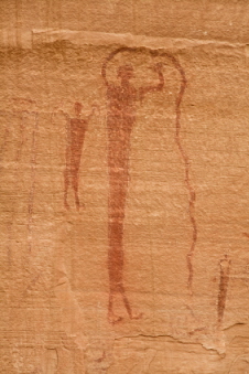
Taking the right fork will lead you directly into Buckhorn Draw. Commanding pinnacles. Overwhelming cliff walls. And you’ll pass right by a 100-foot-long rock wall covered with petroglyphs. Ancient rock art.
Head back to Buckhorn Flat Junction and head east on the same road you came in on. The road forks 2 miles (3.2 km) east of there. The left or north fork takes you through an amazing array of buttes, mesas, and pinnacles. It connects with Highway 6 at a point 16 miles (25.7 km) north of the town of Green River.
Taking the right fork will lead you directly into Buckhorn Draw. Commanding pinnacles. Overwhelming cliff walls. And you’ll pass right by a 100-foot-long rock wall covered with petroglyphs. Ancient rock art.
Crack Canyon
Crack Canyon is found north of the town of Hanksville off Highway 24. (See the map link below). At the extreme southern edge of the Swell. Take the Goblin Valley turnoff on Highway 24 and head west on the paved road for about 5 miles (8 km).
At the T-junction where you would turn left and go to Goblin Valley, keep going west on the Temple Mountain Road. It will turn into a dirt road. Take this road for about 2 miles (3.2 km) until it forks to the left (southwest) to get to the trailhead. In dry weather, most cars shouldn’t have a problem on this road.
A hike through Crack Canyon will get you away from the crowds so prevalent on many of the other hikes in the area. Years of weathering on the sandstone walls of the canyon have created some awesome features. Look for pot holes along the trail. There are many nooks and crannies to explore on this hike.
You can make this anything from a short easy hike to a much longer more strenuous one. To see most of the features of the canyon, plan on several miles and about 2-3 hours.
Little Wild Horse Canyon/Bell Canyon
The Little Wild Horse Canyon/Bell Canyon loop hike is the most popular hike in the San Rafael Swell. They are two of the best slot canyons in Utah. And the hike is suitable for just about everyone.
Little Wild Horse Canyon is located in Emery County between the towns of Green River and Hanksville. The Little Wild Horse Canyon/Bell Canyon loop hike is 8 miles (12.9 km) round trip. About 4 hours to complete.
If you like walking, you’ll probably have no problem completing this hike. You can hike these canyons individually for a short distance. Or connect them together for an excellent half-day loop hike.
Camping and Accommodations
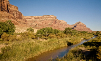
12 ½ miles (20.1 km) from the fork at The Buckhorn Flat Junction – on the Buckhorn Wash Road - you’ll reach the San Rafael River.
And across the river, the San Rafael Campground. It’s a primitive campground with tables and outhouses. But no water. Make sure you pack plenty of water in or bring a water purification system.
If you don’t want to camp, there are hotels and motels located at either end of the San Rafael Swell. At the north or northeast end in Castle Dale or Price. And at the east end in Green River.
Getting to the San Rafael Swell
Head south from Salt Lake City on I-15 towards the town of Price. Price is up the canyon on Utah Highway 6. Exit on U.S. Highway 10 towards Castle Dale. Just before you reach Castle Dale, turn left (east) between mileposts 39 and 40. You’ll see a large wooden corral.
You’ll also see a sign for Buckhorn Wash/Wedge Overlook. Drive 13 miles (21 km) on a dirt road. Head right (south) at the fork to go to the Wedge Overlook.
Stay on the main road for 11 miles (17.7 km) to get to Buckhorn Wash. You'll cross over a dried-out riverbed. Always read the signs.
A great day’s drive would take you from Castle Dale through the San Rafael Swell (and across the San Rafael River) and down to Goblin Valley State Park. And directly southwest of the Swell, you’ll find
Capitol Reef National Park .
Utah is full of fantastic places to hike, bike, camp, horseback-ride, and look at Native American petroglyphs. But the San Rafael Swell gives you all of them in one great area. And without the crowds.
April through early May is the ideal time to visit. After winter and before the summer heat hits.


Bryce Canyon National Park

Canyonlands National Park

Wasatch Mountains

Lake Powell

Zion National Park

Arches National Park

Great Salt Lake

Monument Valley