Tony Grove

Picturesque Tony Grove Lake sits at the top end of a seven-mile long paved road leading off from the Logan Canyon National Scenic Byway . You’ll find the road to the lake 19.2 miles up the canyon from the town of Logan.
The road climbs 2,300 feet to Tony Grove which sits at an elevation of 8,100 feet. Right near the lake is a wonderful 39-unit campground. There’s also a horse ramp and a modern paved parking area right beside the lake. The campground is usually open from July 4th through October 1.
The nearby Mt. Naomi Wilderness Area was designated in 1984. It covers 45,000 acres. And includes a real-life museum of glacially-sculpted cliffs, basins, valleys, and small lakes.
The area includes some of the most stunning … and harsh … country in the Bear River Range. Several trails leading away from the lake provide numerous wildlife viewing possibilities, colorful wildflower displays, and breathtaking views.
There are four trailheads close to the lake:
- Naomi Peak - this trail leads into the Mount Naomi Wilderness area. It is just over 3 miles to the top. A good trail through colorful wildflowers but challenging. At 9,980 feet, Naomi Peak is the highest point in the Bear River Range. When you reach the top, your breath will be taken away … both from the hike and the view. Stunning views of the surrounding mountains and the Cache Valley greet you. My wife and I hiked this trail to the top in September of 2011. The wildflowers were amazing. There wasn’t a cloud in the sky. Temperatures in the low 70’s. Very few people. About 4 hours up and back. A great way to get your mind off your troubles.
- Coldwater Spring - 1.9 miles one way. A well-shaded trail leading through spruce and aspen near the spring. Great views of the Mt. Naomi Wilderness and Logan Canyon.
- High Creek - this trail leads you to a beautiful glacial lake encircled by towering cliffs at 9,000 feet. 10 miles one way from the Tony Grove Loop, it’s a popular horseback trail. It parallels a lively mountain stream running through a riparian forest.
- White Pine Lake - leads to a high glacial lake through the middle of intensely hued fields of wildflowers. The lake sits surrounded by high mountains and cliffs. It is 3.4 miles one way. And ends at 8,400 feet.
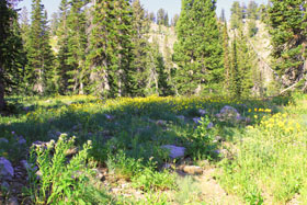
If you head up any of the trails leading away from the lake, you won’t have to go far to see a wildflower eruption. Although normally at its best in mid-summer, the extra wet winter and spring of 2011 delayed this year’s display. It was still in full bloom in early September.
Tony Grove got its name when it became a popular summer retreat area for wealthy Logan residents in the late 19th and early 20th century. They would travel up the canyon and spend as long as 6 weeks up here. “Tony” was 1920’s slang for “high-class” people.
Back to top
Back to Logan Canyon National Scenic Byway
Back to Home Page


Bryce Canyon National Park

Canyonlands National Park

Wasatch Mountains

Lake Powell

Zion National Park

Arches National Park

Great Salt Lake

Monument Valley